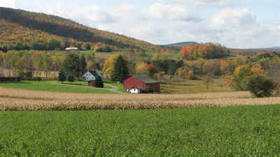
Carbon County, Pennsylvania
Carbon County Education, Geography, and History

Carbon County is a county located in the state of Pennsylvania. Based on the 2010 census, the population was 65,249. Its county seat is Jim
Thorpe.
Carbon County is included in the Allentown-Bethlehem-Easton, PA-NJ Metropolitan Statistical Area, which is also included in the New
York-Newark, NY-NJ-CT-PA Combined Statistical Area. It is considered part of the state's Coal Region, though the eastern and northeastern
sections are considered part of the Pocono Mountains. Some consider lower Carbon County, including Palmerton and Lehighton areas, as part of
the Lehigh Valley.
Etymology - Origin of Carbon County Name
Named for the extensive deposits of coal in the region.
Demographics:
County QuickFacts: CensusBureau Quick Facts
Carbon County History
Created on March 13, 1843 from parts
of Northampton and Monroe Counties. Its name alludes to its deposits of coal.
Jim Thorpe, the county seat, was originally incorporated on January 26, 1850 as
the borough of Mauch Chunk, an Indian named meaning Bear Mountain. It was
renamed in 1954 for the famous Indian athlete, Jim Thorpe, who is buried there.
Consisting largely of land Pennsylvania obtained by the Walking Purchase from
the Delaware Indians in 1737, it was the scene of Moravian missions to the
Indians, frontier fighting during the French and Indian War, and Tory raids
during the Revolution. The Lehigh Coal and Navigation Company, formed in 1822,
built an economic base, and Mauch Chunk flourished. Wealthy canal boat builder
Asa Packer led the movement to create the county. In 1851 he formed the Lehigh
Valley Railroad and broke the Navigation Company's control, although it revived
after another railroad opened the Lackawanna Valley as a route for transporting
coal to New York. When New York tycoon J.P. Morgan bought the Lehigh Valley
Railroad in the late 1890s, millionaires left Mauch Chunk and the area declined.
Deep coal mining lasted until 1973. Always producing high quality anthracite,
the county still is an area for surface mining. Zinc mining became important
after 1898, and the forests produce good lumber. But this is not an agricultural
county; only 9 percent of the land is farmed. The population peak, 63,380,
occurred in 1930. The Northeast Extension of the Pennsylvania Turnpike and the
thriving tourist attractions of Mauch Chunk sustain the present economy. Women's
clothing is the largest manufacturing business. The value added to the economy
by manufacturing in this county increased 67 percent between 1987 and 1992.
Geography: Land and Water
As reported by the Census Bureau, the county has a total area of 387 square miles (1,003 km2), of which, 381
square miles (987 km2) of it is land and 6 square miles (16 km2) of it (1.60%) is water. Blue Mountain forms the
southern boundary of Carbon. The northeast area of the county is located in the Pocono Mountains and the northwest
area includes portions of Broad Mountain and Spring Mountain. It is drained by the Lehigh River except for a small
area in western Packer Township and the borough of Lansford that are drained by the Still Creek and Panther Creek,
respectively, into the Little Schuylkill River and the Schuylkill River, and the Audenried area in the northwest
corner that drains into the Susquehanna River via the Catawissa Creek.
Neighboring Counties
Bordering counties are as follows:
- Luzerne County (north)
- Monroe County (east)
- Northampton County (southeast)
- Lehigh County (south)
- Schuylkill County (southwest)
Education
Community, junior and technical colleges
Lehigh Carbon Community College – Carbon Campus, Nesquehoning


