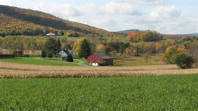
Juniata County, Pennsylvania
Juniata County Education, Geography, and History

Juniata County is a county located in the state of Pennsylvania. Based on the 2010 census, the population was 24,636. Its county seat is Mifflintown. The county was created on March 2, 1831, from part of Mifflin County and named for the Juniata River.
Etymology - Origin of Juniata County Name
It was named for Governor Thomas Mifflin.
Demographics:
County QuickFacts: CensusBureau Quick Facts
Juniata County History
Created on March 2, 1831, from part
of Mifflin County and named for the Juniata River. The Indian name Juniata is
said to mean "people of the standing stone." Mifflintown, the county seat, was
laid out in 1791 and incorporated as a borough on March 6, 1833. It was named
for Governor Thomas Mifflin.
Squatters settled here and were evicted by the provincial government in 1750.
After they returned, Indians raided them in 1755-1756. There was protection from
Forts Bigham and Peterson, but the Indians captured Bigham. The Pennsylvania
Canal was the backbone of the early economy beginning in 1826, followed by the
Pennsylvania Railroad in the late 1840s. The canal closed about 1900, and the
Tuscarora Valley Railroad closed in 1934. Small clothing manufacturing continues
to the present, but kosher poultry production is the biggest industry. Juniata
is the fourth largest poultry-producing county in the state. Farms cover 36.6
percent of the land.
Geography: Land and Water
As reported by the Census Bureau, the county has a total area of 394 square miles (1,019 km2), of which, 392
square miles (1,014 km2) of it is land and 2 square miles (5 km2) of it (0.50%) is water.
Neighboring Counties
Bordering counties are as follows:
- Snyder County (north)
- Northumberland County (east)
- Dauphin County (southeast)
- Perry County (south)
- Franklin County (southwest)
- Huntingdon County (west)
- Mifflin County (northwest)
Education
There are two public school districts in Juniata County: the Juniata County School District and the Greenwood School District. Both of these are K-12 schools. The Greenwood School District serves Greenwood Township and parts of Perry County and the Juniata County School District serves the rest of Juniata County.


