Arizona State Almanac: Facts and Figures
Quick Facts, Figures, and Overview of the State of Arizona

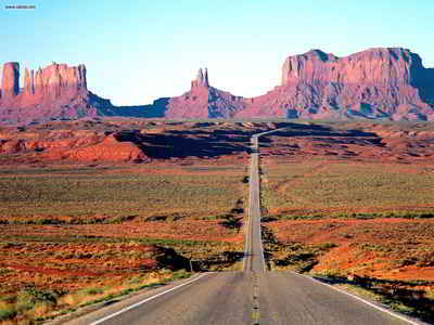
Arizona is one of the Mountain states of the US. The Grand Canyon State shares its boundaries with California, Nevada, New Mexico, Utah, Colorado, and the Mexican province of Sonora. Famous for its beautiful scenery, Arizona has many natural wonders, including the Grand Canyon. Arizona is covered by tall, rugged mountains in the north, and the central plateau gives way to the magnificent desert landscapes of the south. Arizona's name come from combination of two words from the Papago Indian dialect of the Pima language; "Aleh" and "Zon" together as "Aleh-zon" meaning "little spring."
The ancient history and traditions of this land reaches back thousands of years, and today, this state is a favorite stop for golfers and tourists, especially those seeking warm weather. Also, it remains one of the most popular retirement destinations on the planet.
Manufacturing has become Arizona's most important industry. Principal products include electrical, communications, and aeronautical items. The state produces over half of the country's copper. Agriculture is also important to the state's economy. Top commodities are cattle and calves, dairy products, and cotton. In 1973 one of the world's most massive dams, the New Cornelia Tailings, was completed near Ajo.
Arizona Almanac: Facts about Arizona |
|||
|---|---|---|---|
| Official Name | Arizona | ||
| Capital | Phoenix | ||
| Nicknames | Grand Canyon State ...and more | ||
| Motto | Ditat Deus (God enriches) | ||
| Location Region |
33.54255 N, 112.07139 W Rocky Mountains Southwestern |
||
| Constitution Ratified | 1911 | ||
| Statehood | February 14, 1912 48th state |
||
| Population | 6,392,017 (2010) 45.15 sq. mi. 20th |
||
| Largest City (by population) |
10 largest cities (2010): Phoenix, 1,445,632; Tucson, 520,116; Mesa, 439,041; Chandler, 236,123; Glendale, 226,721;Scottsdale, 217,385; Gilbert, 208,453; Tempe, 161,719; Peoria, 154,065; Yuma, 90,041 | ||
| Bordering States | North: Utah East: New Mexico South: Mexico West: California and Nevada (The Colorado River forms much of the W boundary) |
||
| Major Industry | mining (copper, molybdenum, gold, and silver), manufacturing, and tourism | ||
| Major Rivers | Colorado River, Little Colorado River, Gila River, Bill Williams River | ||
| Major Lakes | Lake Mead, Lake Havasu, Lake Mohave, Theodore Roosevelt Lake, San Carlos Lake, Lake Powell | ||
| Arizona Counties | 15 Counties in Arizona | ||
| Largest County (by population) |
Maricopa County 3,635,528 (2005) 9,204 sq. mi. |
||
| Largest County (by area) |
Coconino County 18,562 sq. mi. |
||
| State Parks | 28 | ||
| Electoral Votes | 10 (as of the 2004 Presidential Election) | ||
| US Congress | 2 Senators; 8 Representatives | ||
| Time Zone | Mountain Standard Time Arizona, non-Navajo, no Daylight Saving |
||
| Zip Codes | NANPA | ||
| State Quick Facts | Census Bureau Quick Facts | ||
Arizona Climate and Weather |
|
|---|---|
|
Arizona's weather is popularly categorized as hot and dry, but what most people outside the state don't realize is that Arizona's climate is actually quite varied. While Central Arizonans are basking in mild weather with cool breezes in January, folks in Northern Arizona might be swooshing down the state's ski slopes enjoying a cool winter day. And in the summer, Southern Arizonans could be sunbathing, while people in North-Central Arizona might slip on sweaters and enjoy the crisp night air. |
|
| Highest Temperature | 128 degrees June 29, 1994 - Lake Havasu |
| Lowest Temperature | -40 degrees Jan. 7, 1971 - Hawley Lake |
| Avg. Temp: High - Low |
105 degrees 66.9 degrees |
Arizona Points of Interest |
|
| Arizona offers a myriad of things to see-and-do, including the Colorado River, Grand Canyon, Lake Havasu and the London Bridge, Meteor Crater, Monument Valley, Painted Desert, Sonoran Desert, city sights of Phoenix, Scottsdale, Tucson, as well as plenty of sunshine, golfing, hiking, swimming, and so much more. | |
Arizona Highest, Lowest, and Mean Elevations (Feet) |
|
| Mean Elevation: 4,100 feet | |
| Highest Point: Humphreys Peak: 12,633 feet
|
|
| Lowest Point: | Colorado River 70 feet |
Arizona Land Area (Square Miles) |
|
| Geographic Center | In Yavapai County, 55 mi. ESE of Prescott Longitude: 111°47.6'W Latitude: 34°1 8.5'N |
| Total Area | 113,998.30 sq. mi. 6th |
| Land Area | 113,634.57 sq. mi. 99.69% |
| Water Area | 363.73 sq. mi. 0.31% |
| Forested Land Area | 27.4% |
| Dimensions (Length - Width) |
400 miles - 310 miles |


 Humphreys Peak is the highest peak
in Arizona. It rises in the Kachina Peaks Wilderness Area, immediately north of Flagstaff. The area is volcanic in origin, as is apparent by the
conal shapes of some of the neighboring peaks, but Humphreys is now heavily eroded, and has lost its symmetry. On a clear day on the summit, the
view to the northwest includes the rim of the Grand Canyon. Usual access to Humphreys is via the Arizona Snow Bowl, a popular ski lodge located just
south of the mountain. It is sacred to several Native American tribes